
Club Flying Site registration check list for
(Old Wainuiomata College)
Club name :Wellington Model Aeroplane Club Inc.
Club MFNZ number :56

Any application for registration of a flying site shall be in writing. Draft club rules and procedures shall be provided.
The following points have been addressed:
| Flying site name | Old Wainuiomata College |
| Latitude Longitude | -41.2560819,174.9507869,2339 |
| Grid reference | n.a. |
| a. That the owner, and other existing or traditional users, consent to model aircraft operations. | Yes |
| b. That the site will be operated safely, having particular regard for public access, walkways, car parking zones, nearby dwellings and animals/stock. | Yes |
| c. That the MFNZ restriction on model aircraft not overflying members of the public can be met with a reasonable safety margin, taking into account the local geography. Additional care shall be taken to ensure the trajectory corridor extending from either end of the runway does not intrude on public walkways for at least 200 metres. If the local geography does not allow this, the Club shall have a safety plan, and marshals located to ensure that landings/take-offs do not occur when the public is at risk. | Yes |
| d. That noise will not become a source of complaints. The MFNZ Noise COP offers guidelines on noise levels that may be tolerated and means of reducing the possibilities of complaints. Occupiers of nearby dwellings should be advised/canvassed, and their general agreement sought if possible. A noise mitigation plan shall be written and be available to be implemented as may be required. | Yes |
| e. That model aircraft operations are not incompatible with the general local environment. | Yes |
| f. The Local Authority and District Plan allows for the operation of model aircraft in the proposed new site. (This can be a complex issue and care should be taken before commitment to a new flying field. The MFNZ Council may be able to offer advice in this area.) | Yes |
| g. That model flying is permitted by CAA under the terms of controlled air space. (The MFNZ holds information concerning this and can advise concerning applications for dispensations) | Yes |
Site Plan
At least one sketch plan (and preferably 2 or 3 with different scales) of the flying site shall be provided, clearly showing the following details:
| a. The location of the proposed site, with either map or GPS co-ordinates. | -41.2560819,174.9507869,2339 |
| b. The distance and direction to the nearest existing model flying site. | 4.5KM to Te Whiti Park, N-NW. |
| c. The flight line, runway and pits areas. | See Attachment |
| d. The car parking and public spectator areas. | See Attachment |
| e. The estimated airspace zone that will be used, and the prevailing wind(s) | See Attachment |
| f. The distance and direction to the nearest noise-sensitive building. | 110M East, Kindergarten |
| g. Natural and man-made hazards, such as power pylons, trees, wildlife. | Pine trees to the East |
| h. Areas of regular public use, such as: sports and playing fields, walkways, picnic areas and the like. | The flying area is shared with general public use |
| I. Residential and/or other built-up areas. This includes schools, churches, prisons and other institutions. | Housing on Northern, Western, Southern and Eastern sides of the flying field |
| j. Areas where stock are grazed. This should also include seasonal restriction, for instance lambing ewes. | No stock |
| k. Areas where RC cars or boats have been known to operate, or may reasonably be expected to operate. | N.A. |
| l. The distance and direction to the nearest airport/airfield/aerodrome. | Wellington Airport, 14.25KM |
Draft club rules and procedures shall be provided
See Attached.
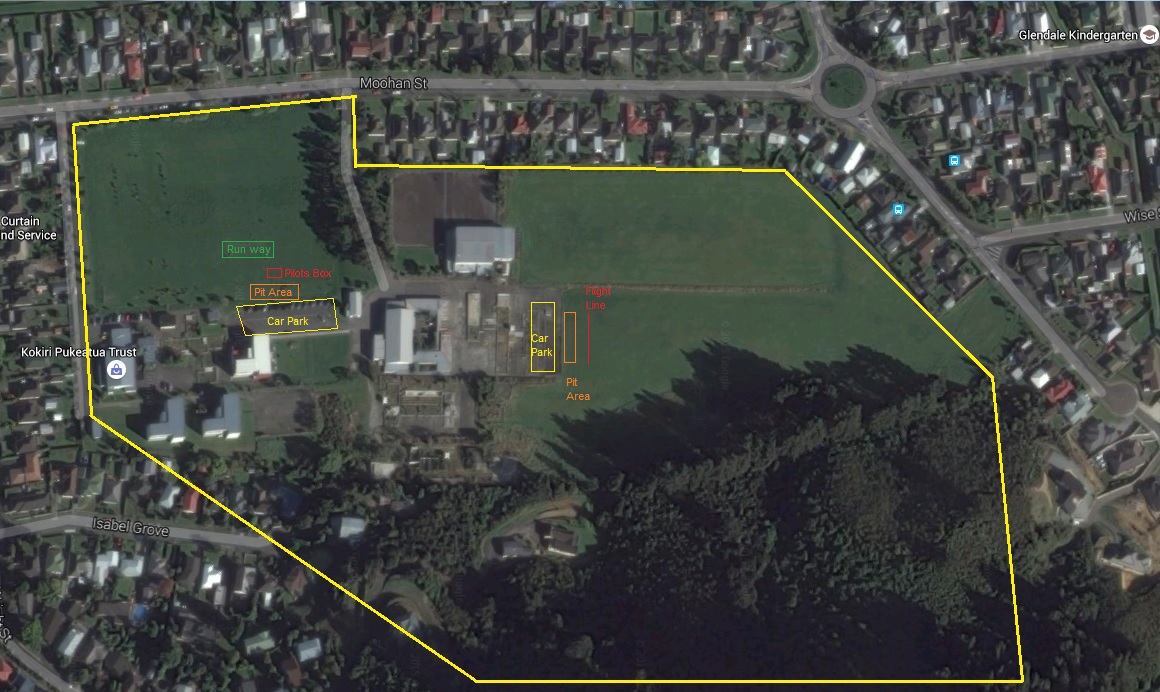
Site Layout