Trentham, Upper Hutt City
General Radio Control power model flying, Helicopters, Multi-Rotors, Thermal Soaring and some limited Free Flight activity.
The Trentham flying site is on the Seddon Rifle Range in Upper Hutt. Before you set out to fly, you can check the web cameras and weather on our Trentham Weather Station. To visit the flying site, head up Fergusson Drive to the traffic lights at Sutherland Avenue and turn right.

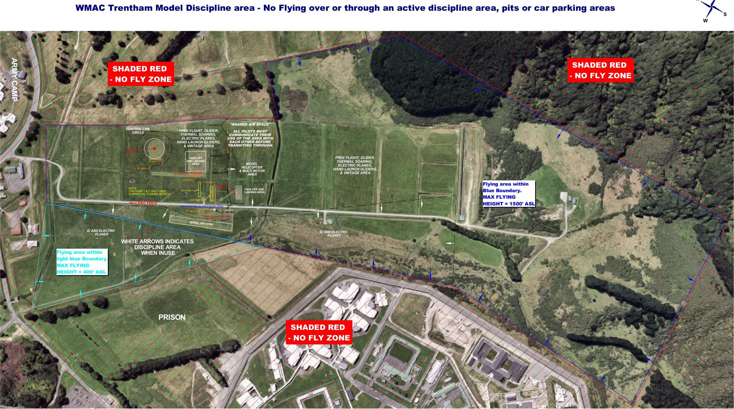
Click on the map for a larger image.
Proceed east along Sutherland Avenue, across the railway line, after which the road becomes Messines Avenue. Keep going until the road curves to the left and the National Rifle Association (NRA) wooden clubrooms appear on your right. Take the gravel driveway to the right (between the sign and the clubrooms) and continue up and over the stop bank.
There is a gate on the other side of the stop bank. If there is a red flag flying and the range is in use, DO NOT enter unless the shooting is taking place at the far end of the range. If there are cars around half the range length, proceed through the gate with caution, leaving it open or closed, as you found it. Travel along the access road, maximum speed 20 km/h, and park adjacent to the clubhouse in accordance with the other vehicles. Stock graze the area so you may find gumboots useful.
DO NOT, UNDER ANY CIRCUMSTANCES, DRIVE OR PARK ON THE RIFLE RANGE MOUNDS. |
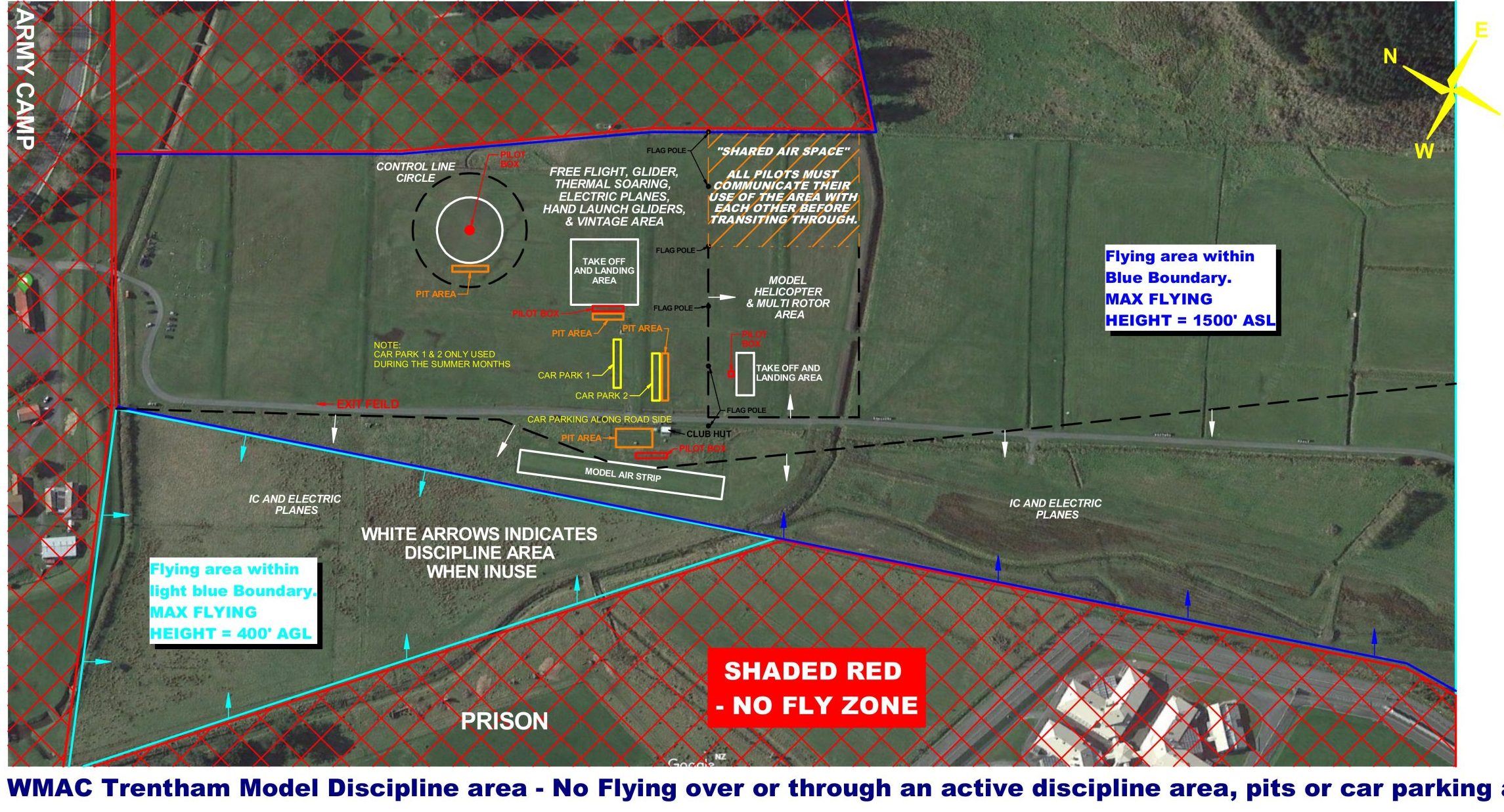
Power flying takes place to the right (west) of the fence nest to the club house. Soaring and helicopter flying usually takes place to the left (east) of the parked cars. Introduce yourself to any club members present and they will make you welcome. You may fly at Trentham if you are affiliated to Model Flying New Zealand (MFNZ), have attained your “Wings” badge, AND there is a WMAC member present. There is a standard MFNZ frequency board in use for those of us not using 2.4GHz RC gear. If you are not using 2.4GHz RC gear please DO NOT turn on your transmitter without the proper peg in your possession.
If you have children with you, please protect them by keeping them away from the aircraft, and please be responsible for them. Dogs are NOT permitted.
We value our relationships with our neighbours, the National Rifle Association (NRA) and its member clubs, the Remutaka Prison and the New Zealand Army. Please do not jeopardise our flying site by flying outside the authorised times, over shooters when shooting is in progress further down the range, over Army property or over the nearby Prison.
It is generally agreed that the increased building and fences surrounding the flying site have made Trentham unsuitable for most Free Flight activities.
Click on the link below to view a map of the Fly and no-fly areas.
Fly and No-fly area
Click on the link below to see a close-up map of the flying field layout.
Field Layout
Whitireia Park, Titahi Bay
Slope Soaring.
When the wind is blowing steadily off the Tasman, then Whitireia Park near the radio masts at the north end of Titahi Bay is the place for a spot of slope soaring.
This world class slope soaring site is designated as a Permanent Danger Area by the Civil Aviation Authority (CAA) and is also recognised as a model flying site by MFNZ.
- Model aircraft operations in vicinity of broadcast aerials at Whiteria park.
- Active by day.
- Altitude: Zero to 1500 feet above Mean Seal Level (AMSL).
The park is open to the public so anybody can fly there. Non-MFNZ affiliated flyers are encouraged to join WMAC, one of the other local model aircraft clubs or at least MFNZ, to ensure they have some public liability accident insurance cover and to help protect our long term use of the site.
To get there, pass through Porirua City, continue along Titahi Bay Road, up Main Road to Bay Drive. Turn right then left into Thornley Sreet and follow it along until it becomes Whitireia Road. At the top of the hill look for where others are flying.

Click on the map for a larger image.
|
PLEASE DO NOT TURN YOUR TRANSMITTER ON UNTIL YOU HAVE FOUND OUT WHAT OTHER FREQUENCIES ARE IN USE. SAFETY IS THE KEY |
To get an idea of weather conditions in the area you can look at Leo DuFlou’s nearby Whitby Weather Station or the Mana Weather site